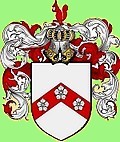
 THE GILBERT FAMILY HISTORY
THE GILBERT FAMILY HISTORY
Little Saperton, Heathfield, East Sussex
Website created by Richard Gilbert, last updated 9 February 2021.
MAIN NAVIGATION MAP
GILBERT; Waldron 1700s & earlier
|
HASSELL; Waldron --
GILBERT; Waldron 1800s --
GILBERT; to the USA
|
SODDY; Sussex & London --
GILBERT; Eastbourne 1800s --
MORRIS; Lewes & Eastbourne
|
HEWITT & HEDGEGOTT --
GILBERT; Eastbourne 1900 onwards --
CLEMENTSON; London
|
GILBERT; in the USA
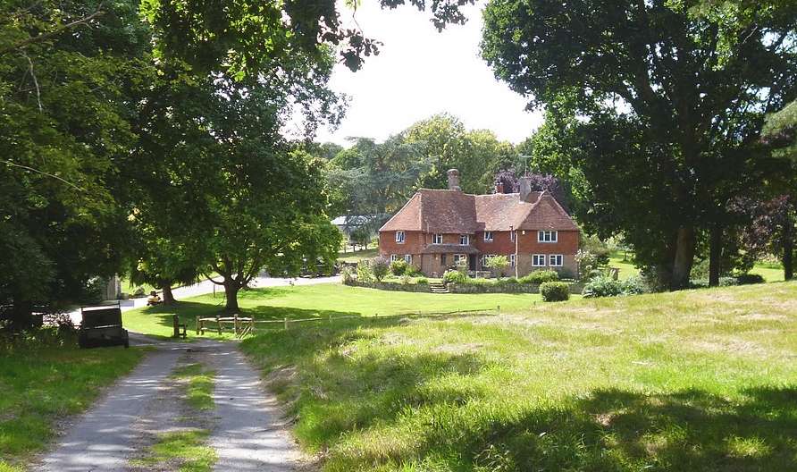
Sapperton Manor Farmhouse. Photo by H R Gilbert, August 2020.

THE MANOR OF SAPERTON
=======================
In Old English (pre 7th century) the word 'Sapperton' means "Settlement of the soap makers". A brief chronology of the Manor of Sapperton;
1200s; Spelled "Sabertona" or "Saperton".
1273; First recording of the "Manor of Saperton".
1387; The Manor of Saperton had a park, which appears to have formed the core of what is now Heathfield Park.
1589; The owner of the "Manor of Saperton" (Thomas Alfrey) died. *
1600s; (when the basis of the present farmhouse was built) Spelled "Saperton", "Saberton" and "Sabberton Manor".
1613 & 1633; Richard Alfrey was the owner (Lord?) of the "Manor of Saperton". *
1650; John Fagg of 'Easthothly', Lord of the "Manor of Saperton", leases some lands to Thomas Pettitt of Wartling.
1851; At the 1851 Census the occupants of "Saperton" (presumably the main farmhouse), Sandy Cross Lane, were Edward
Hobden (aged 40, born Heathfield) farmer and hop grower of 155 acres employing 5 labourers, Harriott Hobden (aged 27) and 5 children aged 1-7,
Edward's father John (aged 82) + 2 workers. Edward (aged 70) was still recorded as the farmer of Sapperton (205 acres) at the 1881 census.
* Interestingly in 1911 "New Sapperton" (see below) was occupied by Phillip James Allfrey.
-----------------------------------
By 1878 the spelling stabilised as "Sapperton" or "Saperton", and subsequently various different locations are mentioned;
SAPPERTON MANOR; Sandy Cross Lane, Heathfield, again a general term for the area. Edward Hobden and his family lived here in the 1880s.
The address is shown as Sandy Cross Lane because the main access was from the north. The drive from Nettlesworth Lane did not appear until
New Sapperton Farm was built in the 1890s.
SAPPERTON MANOR FARMHOUSE; The main building of the Manor. It was Grade II Listed by English Heritage on 12 August 1981. "L-shaped early
17th century timber-framed building, refaced with red brick on ground floor and tile-hung above. Tiled roof, casement windows, two storeys, four
windows, modern matching addition at slight angle." The main drive entrance is in Nettlesworth Lane, through New Sapperton Farm. There is also
a well by the house and a round oast house nearby.
SAPPERTON FARM; i.e. not New Sapperton Farm, but an older property, presumably the farm surrounding Sapperton Manor Farmhouse.
NEW SAPPERTON FARM / NEW SAPPERTON FARMHOUSE; built around 1896. There is no sign of any buildings on the site before this. Nothing is
shown on the 1895 map, but is on the 1897 map. A smallholding encompassing the fields immediately surrounding the farmhouse (today a 4-bedroom
detached house) on Nettlesworth Lane from Old Heathfield to Vines Cross. It has a well. When it was built, the main access to Sapperton Manor Farm
seems to have been altered so that it ran east through New Sapperton to Nettlesworth Lane, instead of north to Sandy Cross Lane (roughly halving
the distance to a main road). A new track was also laid from New Sapperton to Twissels Mill.
SAPPERTON MEADOWS; 14.6 hectare (36 acre) site between Sapperton Wood and Sapperton Farm notified as a biological Site of Special
Scientific in 1991 under the Wildlife & Countryside act.
SAPPERTON WOOD; East of Runtington / Maynards Green, south of Sandy Cross.
To put all the above various places into clarity, here is a map of the area;
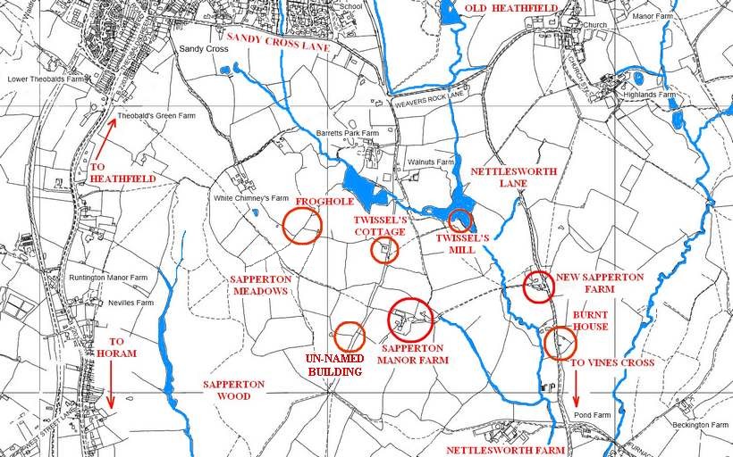
Other locations in the area (and shown on the map above) included;
TWISSEL'S (or TWIZZELS) MILL; a water mill to the north of the main farmhouse.
TWISSEL'S COTTAGE; a cottage near the Mill, still standing and occupied.
FROGHOLE; a small house, briefly occupied, then abandoned and renamed "Lone Barn".
UN-NAMED BUILDING; to the west of the main farmhouse. Probably occupied briefly in the 19th century.
BURNT HOUSE; Aha! Interesting. On the other side of Nettlesworth Lane. See below.
THE GILBERT FAMILY AT SAPERTON
==============================
1823; Elizabeth Gilbert (1823-1853) was born at "Little Saperton". This is the first mention we have of the
Gilbert family living here, and the first mention of "Little Saperton".
Elizabeth's parents were Thomas Gilbert (1791-1851), born in Heathfield and baptised in Waldron, and Mercy Errey (1802-1851), born in
Heathfield and baptised at Heathfield Independent Chapel. They were married in the June and Elizabeth (their firstborn) was born in the
November. Eventually all their 8 children were born at Little Saperton.
 More information about Thomas and Mercy Gilbert and their family
1837; Thomas Gilbert is recorded as having "Copyhold house and land" at "Little Saperton" on the register of electors for Heathfield. "Copyhold" traditionally means being a tenant of the Lord of a Manor.
1841; The Census incorrectly spelled the property as "Laperton".
The occupants of "Little Laperton" were Thomas Gilbert (aged 45, farmer) and Mercy Gilbert (aged 35), and 7 children.
1851; The Census showed the following;
The occupants of "Little Saperton", Sandy Cross Lane, were James Baker (aged 26) farm labourer born in Hellingly, Harriott Baker (23), and 3
children.
This clearly shows that the Gilbert family had left, and in fact they appeared in Hastings in the 1851 Census (March) and were preparing to
emigrate to America a few months later. So they lived at "Little Saperton" from 1823 to 1850.
1861; The Census showed that James Baker, who had been living at Little Saperton, was now living with his wife and
children in "Park Corner" at the east end of Sandy Cross Lane and, instead of being a farm labourer, he had become a farmer of 55 acres.
By 1881 Baker had moved further west along Sandy Cross Lane to "Monkhurst", a building which still stands (Monkhurst Farmhouse).
Had Little Saperton been abandoned for good? And where exactly was it?
SO WHERE WAS 'LITTLE SAPERTON'?
===============================
After plenty of research I am convinced that nearby locations such as Twissel's Mill, Twissel's Cottage and Froghole (later called "Lone Barn") are not relevant; and New Sapperton hadn't been built when the Gilbert family were living there between 1823 and 1850.
But maybe there's a clue in the 1851 census. Only five properties were given the "Sheet number" 442 at that census and they are listed in a particular
order (not alphabetical) which seems to be in a line from south to north. Starting from the south of the area (i.e. closest to Vines Cross) were;
"Dowzers" (in the Hale Farm area, just off the bottom of the above map)
"Nettlesworth" (presumably Nettlesworth Farm)
"Little Saperton" (wherever that was...)
"Saperton" (definitely the main farmhouse)
"Twizell's Mill" (which is the closest to Sandy Cross Lane)
I can imagine that, one day in 1851, the census-taker was given the task of obtaining data from the occupants of the five properties listed on Sheet 442. They started at the south end and worked their way up. You can see the progression on the map above, and this suggests that the location of "Little Saperton" was somewhere between Nettlesworth Farm and Saperton Manor Farmhouse. So what lies there? Only two structures show on maps of the period;
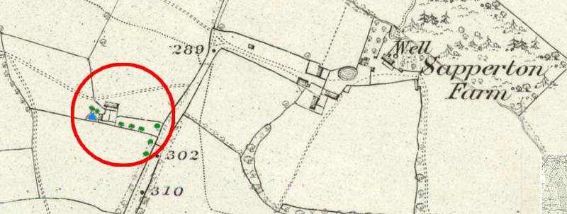
There was an un-named building to the south-west of the main farmhouse. It is visible on the 1875 map (shown above), just off the main north/south path through the area but is not actually named on any maps. It had no well, but the area on the left of the building was a pond. It was still there in 1929 but by 1959 the building had gone. Did anyone live there? Maybe, I don't know.
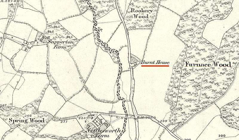
Perhaps more intriguing is "Burnt House" on the other (east) side of Nettlesworth Lane in that little triangular plot alongside Furnace Wood. One or two buildings in that location are shown on every map I have seen from 1813, and it's still there!
Around 2008 the owner of the plot was trying to build a bungalow on the site of a previous (derelict) house and, seeking information about the history of the property, he contacted someone that I have known for many years (and my father knew him even better) - Christopher Whittick, Archivist at the East Sussex Record Office. Christopher came up with some fascinating details;
"...Although you have traced the land tax returns quite correctly through to 1932 showing Goring as owner, the buildings must have been sold off before 1910, since at that date R E Hassell is shown as owner/occupier, as part of Little Sapperton, on the 1910 finance act records..."
So Little Sapperton still existed in 1910, Burnt House was part of it, and it was owned by R E Hassell. Reginald "Reggie" Edward Hassell was a relative of ours, and we know quite a bit about him.
More details about Reginald Hassell's family
Here are more pieces of information from that correspondence, starting with the background to Burnt House.
-----------------------------------
The land known as Burnt House was formerly called "Lovers" and "Pryers" (or "Priors"). Just to confuse things, the property to the north of "Froghole" now known as White Chimneys Farm was formerly called "Lovers Park".
1679; "Tenement, barn, buildings, close, gardens, orchards, and several parcels of arable, meadows, pasture land and wood (40 acres), called
Lovers alias Pryers, formerly in the occupation of Robert Storer, now of Richard Mascall." (From the Wiston Archives, WSCC)
1773 (approx); First use of the name "Burnt House Farm".
1775; "Toft whereon a tenement formerly stood, lately burnt down; barn, oasthouse, buildings, gardens, orchards and eleven parcels of
arable, meadow, pasture land and wood (30 acres) called Lovers alias Priors, formerly in the occupation of James Hope, late of John Reed,
but now of Thomas Waters." (From the Wiston Archives, WSCC). A 'toft', by the way, is an old word homestead.
So now we know why it was called BURNT HOUSE! The Waters family then seemed to have owned it for about a century.
1842; Burnt House Farm was owned by John Farmer and Stephen Waters, occupied by Samuel Reed.
It consisted of; House, garden and yard, house hop garden, little long field, old hop garden, Burnt House meadow, Bridge field, Bridge shaw,
Gingerbread field & shaw, Five acres, Burnt House wood - total 27 acres.
1863; "Cottage, barn, cowlodge, orchard and ten (formerly eleven) parcels of arable, meadow and woodland (27 acres) formerly called
Lovers alias Priors, but now Burnt House Farm and in the occupation of Henry Chrismas." (From the Wiston Archives, WSCC)
It appears that this was the date when the entire estate was acquired by William Allingham of Walworth, Surrey (possibly living 1809-1888) from
the Waters family.
1889; Following the death of William Allingham (around 1888) the trustees of his will put Burnt House Farm up for auction on 8 January 1889
and there are sales particulars for the farmstead which consisted of Bailiffs Cottage, a brick and tiled cowhouse, a large barn, lean-to shed, cattle
hovels, garden, orchard, and a meadow abutting Rookery Wood, all on the east side of the road and amounting to 29 acres.
"The west side of the estate offers an excellent site for the erection thereon of a Gentleman's residence."
Burnt House Farm was sold to John Goring of Wiston, West Sussex for £675. On 19 February 1889 the trustees conveyed the property to Charles
Goring, on whose behalf his father John Goring had made the purchase.
Deeds of Burnt House up to 1898 were found in the Goring family archive.
1907; a house on the west side of the road had been built by 1907 and was offered for sale with 20 acres of land (Lot 13). The land east of
the road was also for sale (Lot 10), described as "An excellent building site". It appeared that Bailiffs Cottage had been demolished when
the house on the west side was built. Major Hassell seems to have bought the plot for £250. Which plot?
1911; Burnt House (not including land east of the road) was again offered for sale, presumably by the Goring family, as the particulars were
found in their family records. The house was described as 'newly-erected' which suggests that Bailiffs Cottage had been demolished and replaced
with something else - the house on the west side of the road?
According to the Land Tax records, 'Proprietors' and 'Occupiers' (but not necessarily the 'Owners'?) of "Burnt House" were;
1821-1822; Steven Waters / Mr Miller
1827-1838; Steven Waters / John Hunt
1840-1863; Farmer Waters / Henry Christmas
1893-1919; Charles Gorring / E Hobden (Edward Hobden was the farmer at the main Saperton Manor Farmhouse)
1919-1922; Charles Gorring
1922-1931; Charles Gorring / R Pettit (Land Tax discontinued from 1932)
No records are shown between 1863 (when William Allingham bought it) and 1893.
The important information there is that, during the period when the Gilberts lived at Little Saperton (1823 to 1850) they were not the owners, nor the proprietors nor the occupiers of Burnt House. So that's the end of that. However the connection with Reggie Hassell is interesting, so here is a bit more about that.
1910; As mentioned, at that date R E Hassell is shown as owner/occupier of Burnt House, as part of Little Sapperton.
According to the Rate Book records, 'Owner' and 'Occupier' of "Burnt House Farm" were;
1921; R E Hassell / E Hurford
1928; R E Hassell / William Luxford
A note at the back of the 1928 Rate Book says "New Property and Assessment Revised...10 September 1928"
1928; R E Hassell / William Luxford.
That doesn't tie up with the land tax records shown above, which suggest that the owner was Charles Goring. But maybe that's the difference between 'Burnt House' and 'Burnt House Farm'.
That's all I know at the moment.